About Tripoli

Known as the capital of the North, Tripoli is Lebanon’s second largest city: from a regional trade capital for the past centuries, the city is nowadays the most impoverished of Lebanon and on the Mediterranean. The city has been scared by the violent clashes and conflict over the past 40 years and is confronted with significant development, economic, and security challenges. The spillover of the Syria crisis and the influx of refugees have contributed to increase social tensions. Tripoli has however successfully preserved its spirit and authentic character: founded by the Phoenicians in the 8th century, and successively ruled by the Franks, the Mamelukes and later the Ottomans, the city is rich of its cultural heritage.

Tripoli metropolitan area

Tripoli is an eastern Mediterranean urban agglomeration 85km north of Beirut composed of three municipalities: Tripoli, Mina and Beddaoui, and 17 cadasters. Tripoli is the official capital of the North governorate and its population reached around 0.49 million individuals. The city occupies a competitive geographical position as the commercial centre of a large rural area.

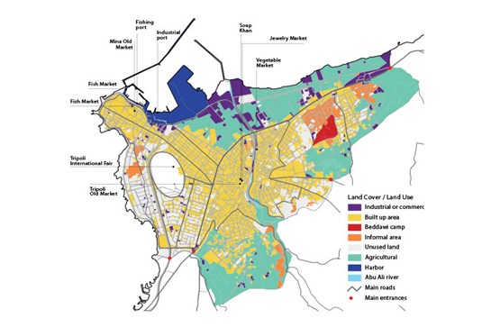
There are 17 cadasters distributed over the three municipalities of Tripoli, Mina and Beddaoui. 58 sub-cadastral neighbourhoods have so far been identified The metropolitan area is 32% built up. Industrial/ commercial uses comprise about 7% of the land use by area.

The Urban core is defined by an inner ring of high population density. It is surrounded by industrial and harbour functions with four informal areas and an official Palestinian camp near metropolitan margins: 32% Urban/Built up, 27% Agricultural, 13% Roads, 2% Empty land, 7% Industrial/Commercial, 4% Informal Area, 5% Other
  • 72211
    Syrian refugee
  • 46 %
    Of the Lebanese in the capital region live in poverty
  • 30005
    Palestinian
  • 504478
    population

About Tripoli

The old city (Tripoli) and the port areas (El- Mina) started to develop in the first half of the 20th century simultaneously. The old city was designed as a deterrent to military invasions. It is a commercial and craftsmanship hub articulated around the mosque and grew separately from the port- Al-Mina. It has a number of protected buildings and sites.

Located 3.6km to the west, the neighbourhoods of Al Mina grew as the harbour serving the city, with a major ship-building, trade and commercial centre for silk and agricultural produce, especially citrus and sugar cane.

Approximately 3km north-east of the city centre is the Palestinian camp Beddaoui. The camp was formed in 1955 and spreads over an area of 1km2, with an estimated current population of almost 30,000 . The camp witnessed a huge population influx from Nahr el-Bared (NBC) after fighting between the Lebanese army and radical militant group, Fatah Al-Islam, forced 27,000 refugees to flee NBC in 2011 , increasing the population in Beddaoui from 15,000 to the double. Beddaoui Camp is managed by UNRWA.. The camp still mostly follows the borders set in 1955, but has also spilled over adjacent neighbourhoods that now provide low income housing over the years to Palestinian refugees and individuals of different backgrounds and nationalities, more recently Syrian refugees.
During the early 1950s, the city grew exponentially due to rural-urban migration. The rural population settled in Tebbaneh and the souks, from neighbouring Sunni Dinniyyeh and Akkar while the richer population moved out of the historical city. The introduction of customs duties by Syria at its frontiers affected the activities of the Port of Tripoli. .

During the civil war from 1975 to 1990, the city witnessed further population movements and displacements that changed the demographic profile of the city. The civil war was also responsible for stopping the oil refinery and the rail train. This further physically and economically segregated the city from its hinterlands as well as from Beirut, which contributed to raising poverty levels within the city. Further, this gave way to an increase in illegal construction and the development of poor enclaves in the city due to deteriorating economic conditions.

About Tripoli History:

  • 8th Century

    The Phoenicians founded Tripoli. It originally comprised three neighbourhoods situated in the current location of Al Mina. It was the centre of a Phoenician confederation with Sidon and Tyre and Arados Island, hence the name “Tripolis”, meaning “triple city”.
  • 10th Century

    The Fatimid Caliph Al-Muiz conquered the city. It became an independent province encompassing Lattakia (Syria), experiencing a commercial and cultural boom that rendered it a significant centre of Shiia.
  • 1109

    Tripoli was conquered by Raymond de Saint Gilles, Count of Toulouse. It became the capital of Tripoli County, one of the main Crusader states, and remained under domination by the Franks for almost two centuries under the name “Triple”.
  • 1285

    The Mameluks were victorious over the Crusaders. The old city was developed near the Citadel far from the old city to protect the Mameluks from invasions. The medina (now the old town) with its narrow alleys was also designed to prevent military invasions. Henceforth, the city grew separately from the port of Mina. It became the second most important Mameluk city after Cairo, and the third Syrian city after Damascus and Aleppo.
  • 1516

    The Ottomans were victorious over the Mameluks. The citadel was reinforced. The souks continued to play their traditional role. City growth continued but at a slower rate relative to the preceding Mameluk era.
  • 19th Century

    Competition between the ports of Tripoli and Beirut increased, with Beirut prevailing from around 1860.
  • 1909

    A road link was created between Tripoli and Beirut.
  • 1911

    A rail connection was created between Tripoli and Aleppo.
  • 1920

    The State of Great Lebanon was declared by General Gouraud, and Lebanon came under a French mandate. The inclusion of Tripoli in this entity was not well accepted by its people.
  • 20th Century [first half]

    Tripoli underwent continued population growth fed by a rural exodus. Rural immigrants tended to settle in Tabbaneh and the souks, whilst well-off existing residents moved out of the historical city.
  • 1955

    The Abu Ali river flooded. Following the flood, a concrete channel was built leading to the demolition of around 2000 residential units, displacing many towards the historic centre. It affected the socio-economic composition of the neighbourhoods in generating migrations of the middle class from Tabbaneh and the old city to the new neighbourhoods. Simultaneously, socio-spatial segregation deepened in the city.
  • 1970s

    The city witnessed progressive de- industrialization. Major infrastructure services ceased to operate with the war (rail connections, fair, refinery).
  • 1980

    The first violent clashes took place between Jabal Mohsen and Tabbaneh. The military intervention of the Syrians rooted the conflict. Syrians shelled Bab al Tabbaneh because of its popular support for the PLO. On its side, Jabal Mohsen is assimilated to the Syrian regime (particularly as the youth of Jabal Mohsen became involved with the Syrian forces). Thus begun the “retaliation game”. This antagonism was marked by the 1986 slaughter when Syrian forces killed 300 people in Bab al Tabbaneh.
  • Tebbaneh suffered deeply from the war

    Tebbaneh suffered deeply from the war, experiencing heavy destruction and migration of a third of its population. The city lost its multi-confessional nature with the out-migration of the Maronite Christians (especially to Zghorta). At the end of the civil war, the urban agglomeration comprises more than 90% Sunni Muslims. Orthodox Christians live in Al Mina and the Alawi minority lives in Jabal Mohsen. With the development of new neighbourhoods along the road linking Tripoli to Mina (Azmi, Miatein, Mina Avenue), the two poles are connected in terms of continuous built up area. However, this has been accompanied by a polarising segregation between the poor ‘old city’ of Tripoli and the more prosperous ‘new city’.